In order to shorten the Biscay crossing, similar to our thinking when leaving the Isles of Scilly, we wanted to get as far south as possible without actually entering the bay too much. We looked at our options and the time that we had before our weather window and decided to aim for Crozon.
This was a short hop down the coast, but we were beating into the wind to get out of Brest which took quite some time.
We have been enjoying our time here in Brest, ended up arriving on Bastille Day and amidst a big maritime festival.Big ships, lots of flags, music and fireworksAlso been sorting out boat insurance (woo)Nearly time for our Biscay crossing!#sailinghannahpenn #sailing #sailinglife #brest #fireworks #liveaboard
We took this opportunity to have a day out on land.
The aquarium was about an hours walk from the marina, so we stocked up on icey cold water, and started walking amidst a bit of a heat wave (around 30 degrees Celcius).
Our walk took us along the rest of Brest harbour, then along a busy-ish road with a cycle path, and eventually through an industrial area until finally reaching Oceanopolis.
The aquarium is split up into 3 main different zones. Tropical, Polar and a zone for the local area.
There were penguins.
Lots and lots of penguins.
Seals.
The cutest of sea otters.
And of course, small fish pretending to be Nemo.
While browsing the shop we found a very cute seal which is now part of team Hannah Penn (also known as Team Saily Mc Sail Face).
Keep an eye out for this cute one in photos to come.
On the way back we tried out a french bike rental app called Donkey republic.
Not many bikes available that worked, most parking places would generally have 5 or so bikes, but only one that wasn’t broken / that you could unlock.
This shortened the trip back quite a bit. Very glad the bike was electric assist.
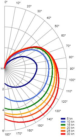
Owners Group Reply: Polar File for weather routing
Has anyone managed to put together a realistic ‘polar file’ for the Nicholson 38? It enables one to interact with weather routing software like Fastseas etc. Any info appreciated, thanks
As I said we have been testing this out with some routes, and had a few learnings.
The main one of those is that if you are fighting against swell, or “larger” waves and chop everything becomes less accurate
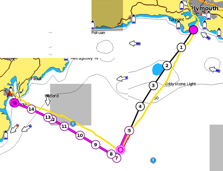
Plymouth to Falmouth
This was up wind all of the way with a single tack part way along as the wind changed slightly. We were sailing on our closest point of sail the whole way, so 60 degrees for the conditions we were in is pretty accurate. This was 1m swell from the west and 15-25 knts generally from the west. With less swell I imagine we could get closer to the wind that 60 degrees.
The route planned was 12h17m and our track for the routed part was 13h, so pretty close
On this screenshot, you can also see 2 other waypoints (blue pins). These were the tacking points for 2 other polars. The right most of these was our custom polar that we made a while back, this it turns out would have been too pessimistic. The leftmost of these was with a 45 degrees as the closest point of sail.
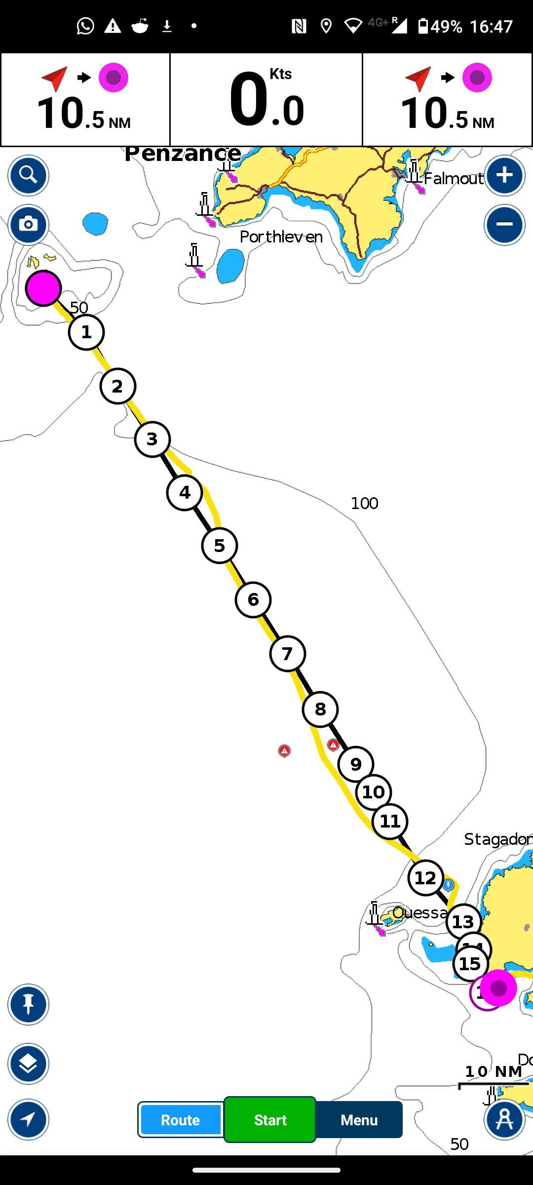
Penzance to the Isles of Scilly
Routed time 8.5h, Tracked time 8 hours We cheated slightly here between points 5 and 6 on the route where we found ourselves with no wind and we motored around the corner a little to find it again. This might explain why we beat the routed time.
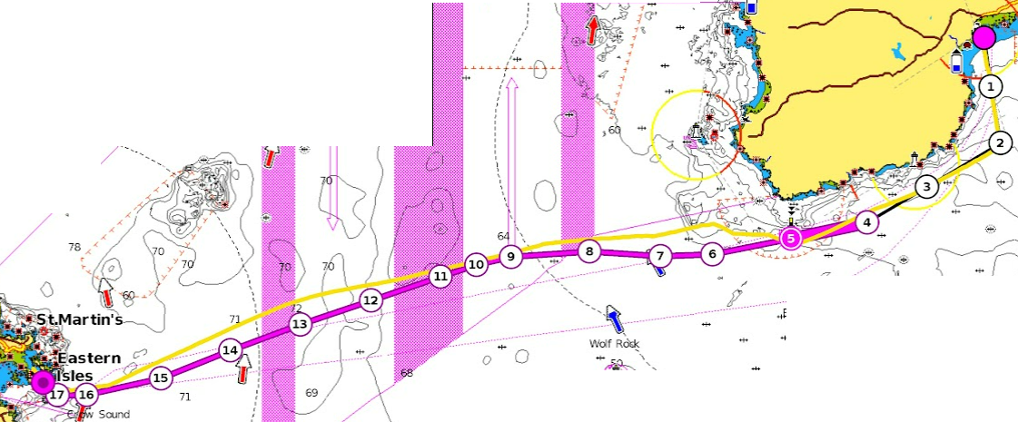
Isles of Scilly to Brest
We had a pretty simple route for this which was mainly downwind.
We ended up hacking to do the odd gybe and gull-winged at points.
The route here was 1d5h and our track along the route was actually only 24h.
At a guess, this was due to the following 1-1.6m swell the whole way pushing us a bit faster. Max land speed here for us was actually 11knts
This meant that not only was the marina in Brest quite full, but also the whole harbour area was extremely busy with classic yachts, ships, music, food and drink.
A tall ship in the harbour of Brest during the festival
As we were walking around the festival we kept hearing bagpipes in the background and wondered where they were coming from.
We ended up at the music stage, but there were no bagpipes to be seen initially.
It turns out they were warming up around the corner, but of course quite loud as bag pipes generally are.
When they came to perform, the band was not only made up of bagpipers, but also people that seemed to be playing what looked like a small clarinet, but it turned out to be (we think) a set of practice chanters.
All quite loud, but also enjoyable.
We walked past what seemed like hundreds of food establishments, all of which were jam-packed.
Eventually, we settled on a pizza place right next to the marina jetty that Hannah was moored up on.
They let us know that firework would be happening at around 11pm, so we set on a bench across the road, and waited both for the fireworks and our pizza with some drinks in hand.
We captured the climax of the fireworks display for you to enjoy.
The restaurant forgot to bring our pizza out (probably distracted by the fireworks) but we collected it shortly after they finished, and headed back to the boat, warming it slightly and then devouring it at about midnight.
We originally considered crossing straight from the English mainland to Brest but decided to head to the Isles of Scilly on day 20, a decision we are still happy with as the Isles of Scilly are beautiful. If anything we wish we could have spent more time there.
After our little morning wake up we set off around 8 am. The plan was for the whole route to take a little over 24 hours, so an 8am start meant we would arrive during the day to Brest.
The whole track was around 140 nautical miles, took 1 day 5 hours with an average speed of 4.7 knots.
It’s always hard to put across what sailing out to sea is like in words, so here are two short clips from different points in time during the crossing.
As we left the Isles of Scilly the sea was extremely flat, as the isles were protecting us from the swell.
As we gained distance from the Isles the swell started to pick up a bit. Here is a video from 14:30 on day 24, 6 hours in.
As we got further into the channel the swell continued to build slightly, and in this clip from 22:44 on day 24, you can see some more rolly larger swells.
Crossing the shipping lanes is always a little bit of fun, especially in the channel where they can be quite busy. You can actually see a large container ship in the background on the video above.
AIS is invaluable here, as all the large ships are required to transmit their location (lots of small boats including Hannah do too). AIS data is displayed within the Navionics app that we use for navigation. Below you can see 2 ships in the channel, their track for the next 20 minutes, as well as where we are.
As we approached France, we put our courtesy flag up (thanks Syliva for hand sewing them all) as the coastline was lit up with lighthouses (very hard to take a picture of). For anyone that doesn’t know, the courtesy flags are a small flag for each country for use when you are in their waters saying that you agree to abide by their laws.
We had to navigate through a rather tidal channel called “Chenal Du Four” which is around 14 nautical miles long and narrows down to roughly 2 nautical miles.
As planned the tide was in our favour, whisking us toward Brest adding around 4 knots to our speed. The top speed on the crossing as a whole was 11 knots over land.
The final part of the passage took us into the entrance to Brest where we tacked all the way up to the rather larger harbour, within which sits Marina du Château.
Initially, our call over VHF to the marina told us there was no room on the visitor pontoons as there was a big event going on that day. We needed to enter the country and the EU so we negotiated a short stop on the fuel pontoon for us to visit the immigration office that is only a 4 minute walk away.
Upon returning the staff had found a place for us within the marina using the spot of another boat that was away for the month, so time to relocate. Our marina track ended up looking a little like this.
Once moored up, we started to relax in the midst of the heatwave, making use of the new handmade wind scoop for the forward hatch (thanks Sylvia).
As mentioned above, we arrived amidst a festival, it also happened to be Bastille day, but we will write about that in the next post! 🙂
Sailed across the channel again today, from The Scilly Isles, to Brest FranceThe ensign (flag) made by @sylviax1957 here with a beautiful mid shipping channel sunset#sailing #sailinglife #sunset #nic38 #camperandnicholsons #thechannel #flag #ensign
We started day 24 at approximately 5 am in an anchorage off Porthcressa Beach, St Marys.
This anchorage is on the southwest side of the island (pictured below). The anchorage is highlighted in green, and roughly where we were anchored is marked with a red dot.
Map showing the location of the incident. Red dot was our anchor location.
We heard a loud thud and scraping on our chain. Looking out of the skylight from bed, we saw another mast oddly close by.
At first, we didn’t know what was going on, had we dragged? No! Our anchor alarm had not gone off. Also, we were on the outside of the anchorage. It must be someone else!
Leaping out of bed and onto deck we discovered that another boat had dragged anchor from further inshore into us!
These hungover French sailors on a Doufort 24ft sailboat didn’t notice themselves dragging and hitting us, and didn’t surface until after we loudly knocked on their hull and already had our fenders out. If they didn’t hit us they would have been taken straight onto the rocks or out to sea.
Initially, they hit the bow roller, chain and snubber before gradually turning to come alongside us.
The bow roller, chain, snubber setup on the nose of Hannah
Once up they also got some fenders out to put between the hulls, engine on and tried pulling up their chain with the electric windlass to find it didn’t work. They pulled it up by hand (something we are used to on Hannah!) with some help from us getting the anchor over the bow.
Judging by how quickly they pulled up the chain they probably only had 10 meters or so of chain out, and we were in 10 meters of depth at high tide. They would have been in 8-10 meters of depth where they were anchored.
Minimal damage, just some light paint scratches on Hannahs’s bow as the metalwork, chain and snubber took most of the hit on the nose and we were on deck before anything else could happen, holding the other boat away from Hannahs’s hull.
The anchor and bow roller when hauled out in 2022, after the new anchor was fitted.
No pictures or videos of the actual event, but let’s hope it doesn’t happen again…
The alarm is very loud and there is no chance of you sleeping through it, just make sure it has a good GPS signal, or you’ll be woken up by the alarm telling you it doesn’t know where it is!
It’s also what shows us what our swing pattern looks like after a night of anchoring.
On Day 22 we were exploring Tresco island, but as August drew closer, we needed to try and get across the channel and Biscay with some good weather. Tomorrow (day 24) looked good for a channel crossing, so we wanted to prepare by getting as far south and east in the Isles of Scilly as possible.
Our anchorage of choice was on St Marys south side, and the route we chose took us through the Isles.
We arrived at our anchorage fairly late and it was quite busy so we anchored on the outside which lead to a slightly rolly night.
Seals of the ScillysMet this little friend on the way back to the boat after some island explorations#sailinghannahpenn #sailinglife #seals #thescillyisles #seallife #water #calm